IT tools
Some of our developed IT tools

The project (INFOROAD ΚΜΡ6-0079153) scope is to develop a comprehensive tool and method for the detailed recording, mapping and monitoring of the forest and rural road network. INFOROAD is co-financed by the European Union and Greece under the framework of the Action “Investment Plans of Innovation” of the Program “Central Macedonia 2021-2027”. INFOROAD is an integrated tool to support decision-making in coping with natural disasters and crises, the sustainable management of the road network and the best possible utilization of forest and agricultural resources. Investment’s total budget is 354,500.00 € out of which 326,020.00 € is public expenditure.
INFOROAD is an integrated tool that:
- Identifies problems in the road network for its faster restoration.
- Supports decision-making in response to natural disasters and crises (e.g. facilitate fire suppression operations and the safe and efficient movement of firefighting forces).
- Supports the sustainable management of the road network.
- Promotes areas of tourist and archeological interest.
- Supports the development of special forms of tourism (e.g. cycling tourism) and other sports and leisure activities.
- Contributes to the development and utilization of ecosystem services.
- Ensures easy and safe access to agricultural and livestock farms, in rural and forest areas.
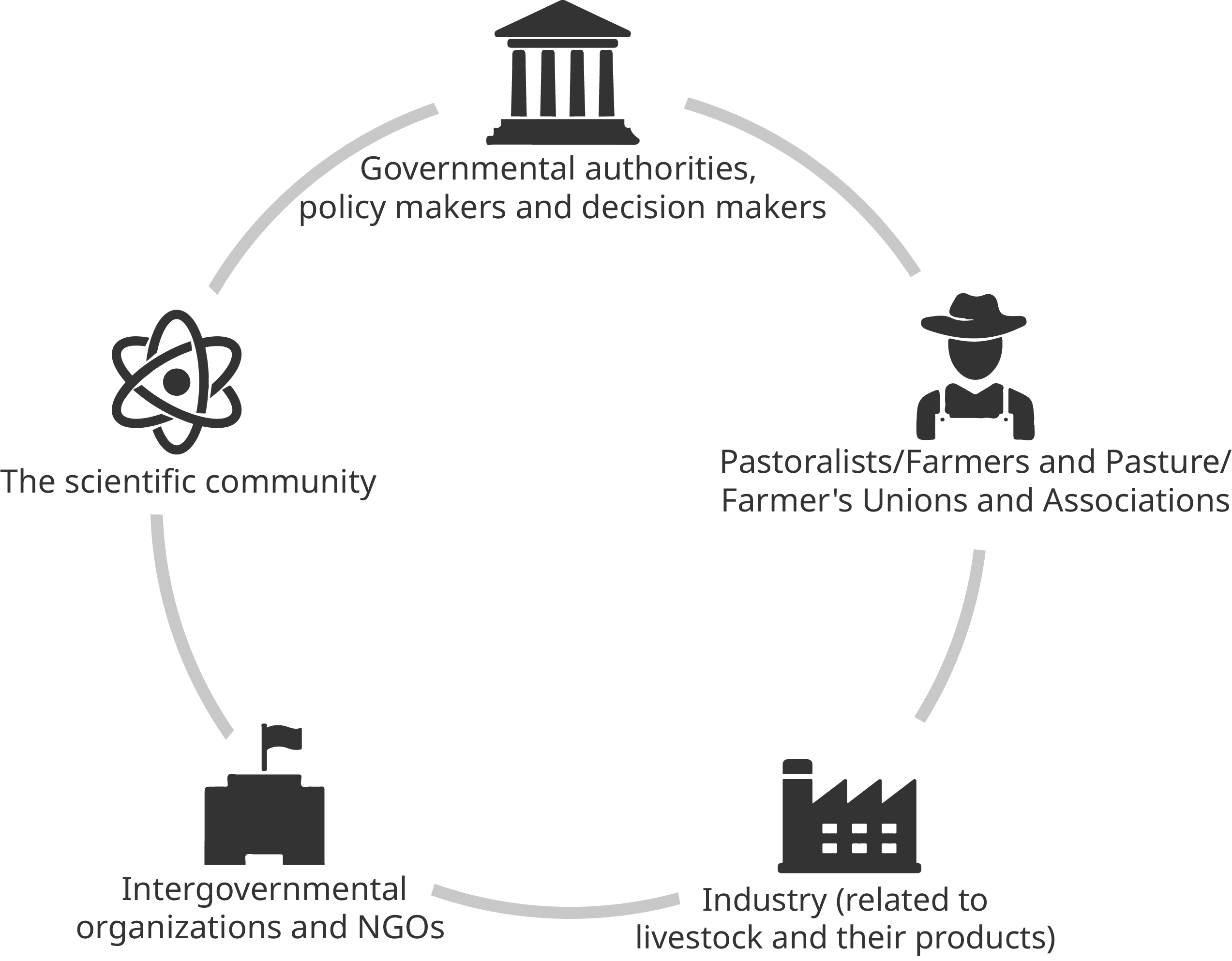
INFOROAD will address the needs of the:
- Civil Protection
- Regions and local administrations
- Forest and Fire Services
- Other stakeholders (e.g. foresters, agronomists, farmers, traders of forest/agricultural products, mountaineering clubs, associations/organizers of mountain bike-motocross races, residents, visitors/tourists, people with disabilities, etc.)
Earth Polis is an independent WebGIS tool. It provides users with online access to spatial data, at any time and from anywhere. Local authorities, public utilities, private companies and citizens can use it to visualize, query, analyze and interpret data, in order to understand relationships, patterns and trends.
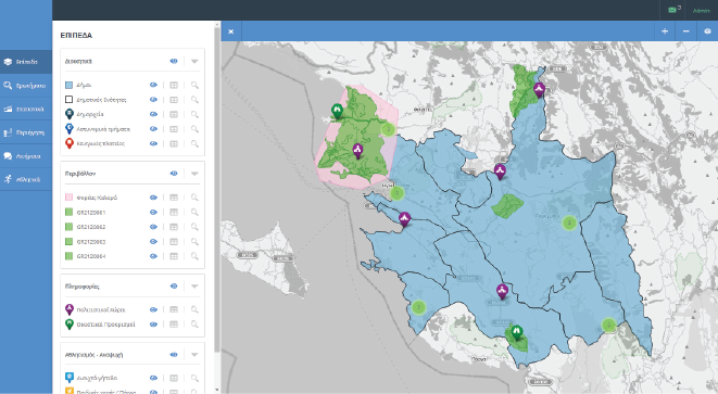


TOOLS
Layers managementThe user can manage the available geographic data layers, enable and disable them according to his requirements and access their descriptive data.
Citizens requestsThe citizens are given the option to depict geographically a point of interest and then fill in the appropriate form and report a specific problem that has been identified in the region (tool for local government).
Creating queriesThe user can create queries, using the available geographic data layers, depict the results of queries, adjust the visualization styling, etc.
StatisticsThe user can produce statistics for each field, such as minimum, maximum and mean values, standard deviation, etc. and conclude to classifications by different methods, such as equal ranges, natural break etc.
TouringTourists and visitors of an area can create routes to follow, with points of interest, for which detailed information is provided through the platform with text, photos and video.
The SenSPa tool is an on-line system that targets to assist sustainable pasture management, decision making, planning of activities and in the long-term pastures’ restoration by providing useful, up to date information for sustainable pasture management. The information will be available to local and national public administrations, public and private stakeholders and end-users. SenSPa won in 2021 the Information and Knowledge thematic category of the Disruptive Tech Challenge 2021, which was administered by the World Bank.

SenSPa provides added-value, cost-efficient and real-life-tangible solutions to various user categories:
The SenSPa tool is processing continuously updated satellite data along with ancillary data in order to provide useful, up to date information for sustainable pasture management. The main products that are provided to the users are:
- Forage Production
- Grazing Capacity
- Plant Cover
- Pastures Condition
- Vegetation Indices and Band Ratios
The SenSPa tool primarily targets Central Asia and neighbor countries. Nevertheless, the tool has global application and can be used for several activities:
- Sustainable pasture management: facilitates stakeholders in monitoring and managing pastures sustainably
- Livestock management: assists livestock farmers to manage their herds more efficiently
- Policy making: assists governmental authorities and policy makers in decision making and planning of the long-term pasture management or restoration
- Research: assists researches to retrieve data and facilitate their research
- Cost-efficient, web-based service
- Accessible from any computer or smart device
- Use of up to date information
- Wide range of features and pasture related products
- Wide range of applications
- Supports sustainable pasture management and improved grazing management
- Increase of livelihood

EcoServe is a Fleet / Ground support equipment management optimization tool targeting fuel economy in ground handling services.

- Real-time GPS tracking and operational data collection using custom-made tracking devices implemented on GSEs
- Refueling data collection utilizing an interactive user-friendly dashboard
- GSE maintenance, flight info and ground handling services data monitoring by automated connection to ground handling company’s database
- Fuel consumption modelling using GSE trip tracking data
- Real-time and historical GSE trip data (mileage driven, engine operational time) and flight info visualization in the airport map
- Trip, operational and refueling data analysis and assessment
- Refueling data control by comparing with fuel consumption modelling
- Key performance indicators evaluation for fuel consumption of ground handling services
- Alerts and notifications for significant deviations on fuel consumptions, irrational refuelings, unreasonable maintenance events, recorded data errors
- Online tool with admin and reporting export capabilities, valuable and user-friendly analytics and dashboards for an integrated GSE energy management
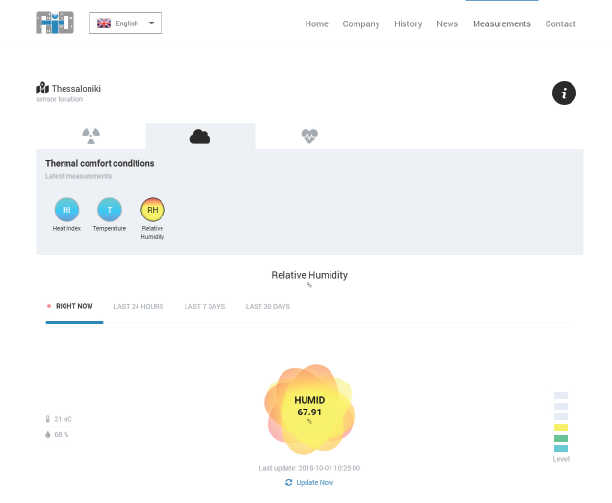
AID is an Innovative Real Time Air Quality Monitoring System consisted of multiple measurement stations and an interactive multi-agent network with main target to assess air quality and environmental conditions and support decision making and action implementation for public health protection and air pollution mitigation.


Real-t-SO is an Innovative Real Time Information System consisted of an interactive multi-agent intelligent network with main target to monitor and control both seawater intrusion and waste water overflows in Combined Sewer systems in coastal cities.

The real time monitoring of seawater intrusion and waste water overflows, the continuous support of the sewage company in dealing with these issues and the direct implementation of corrective actions mainly related to the operation of the electromechanical equipment within the Combined Sewer system.
The system receives and assesses real time measurement data from multiple environmental sensors in order to:
- Inform the staff of the sewage company about the combined sewer system’s operational conditions
- Predict undesired conditions (e.g. weather conditions that can lead to seawater level raise and consequently to seawater intrusion)
- Alert in cases of wastewater overflows and/or in cases of seawater intrusion
- Decide in real time the appropriate corrective measures (e.g., moving gates, etc.) during critical conditions and implement a series of actions till the desired state of the combined sewer system is re-established